We’re staring down one last tranquil weather day before our weather drastically changes. We’re in and out of the clouds Monday, but they should let up around 2 p.m. This will be around the peak heating of the day, so high temperatures approach 60 degrees.
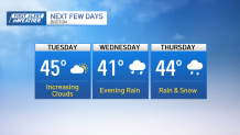
Throughout Monday night, a weaker weather system to our south will bring clouds back into the picture, but Tuesday’s focus is primarily onshore flow keeping temperatures near the coast, in the low 40s. Further inland, highs touch the upper 40s before overcast and cloudy skies build back in.

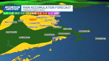
Heavy rain expected in eastern Mass.
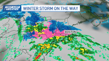
The upcoming storm will be fairly messy. While the storm will carry gust winds at the coast up to 55 mph, heavy rain is also likely too. Showers erupt late Wednesday and are around all day Thursday. We’ll pick up 2-3 inches of rain between Wednesday morning and Friday evening. This is coming off the sixth wettest month of March, so river and basement flooding will need to be monitored again. Where the air is just even slightly cooler — greater Worcester and through Nashua, New Hampshire — snow and sleet are probable.

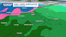
Snowstorm for parts of Massachusetts
Local
While amounts are still very much in flux, the tendency of the storm will be to start as sleet late Wednesday and progress to snow Thursday before dawn. It’s likely we see between 2-4 inches of snow in northern Worcester County, with higher amounts through the lower Merrimack River Valley.
It will take some time for the storm to depart, which means clouds and cool air linger through Friday and Saturday.

While we have our eyes on the upcoming storm, we’re also watching a broad area of high pressure is in view early next week.
Trends right now favor dry skies and warm weather for the eclipse and Red Sox home opener early next week.


