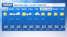
New Englanders celebrate a dry weekend as more sunshine covers us this afternoon and temperatures grow above average. We’re tracking highs around and in the low 60s today with variable clouds and a light NW wind.
We’ll keep enjoying dry weather through Monday, however, temperatures should dip after the passage of today’s cold front as well as a push of an onshore wind. This will keep temperatures in the lower 50s along with mostly cloudy skies. The chance of rain will increase Monday night into Tuesday morning.

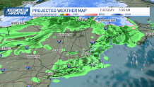
Scattered showers will move in Tuesday morning with another round Tuesday evening for parts of the southeast. But as our warm front pushes northeast, we’ll also be set for above average highs that will only last us for a day.
Highs will climb to about 65 and upper 60s among the warmest of the spots located south.

A cold front will dip south right after allowing the entrance of colder air that will crumble our highs back to the 40s and 50s Wednesday. Although temperatures will cool down significantly by Wednesday, skies will remain mostly sunny.
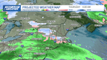
The forecast grows interesting when we track our next low pressure system moving in Wednesday night into Thursday morning.

This will push in moisture and the cold temperatures in place may allow for snow in the higher elevations among the Berkshires and Worcester hills to a wintry mix further east nearing I495. If that wintry mix materializes, we’ll likely see it rapidly coming to an end as temperatures Thursday afternoon will go back up to near 50 while rain will shield southern New England before the system exits.
Friday will keep highs in the mid 50s with more showers incoming that evening into Friday night. Our following weekend is trending slightly below average with highs in the low 50s with decent sunshine.


