Friday has arrived and the timing couldn’t be better. This time around, southern New England will enjoy dry conditions and milder temperatures.
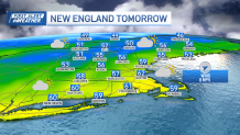
We begin our rise in temperatures Friday afternoon, with highs reaching the mid-50s, which is close to target for our average high. The high pressure system over us is moving offshore, leading to a shift in wind flow to the southwest. Winds will gust up to 25 mph, especially near the eastern side of Massachusetts.
Skies clear out Friday afternoon, and our warm-up in the mildest areas will take us to the upper side of the 50s south. A few more clouds will cover us overnight, keeping lows in the upper 40s for Boston with lower 40s west.
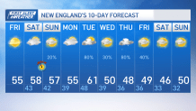
Regarding our weekend, temperatures go up near to slightly above normal.

There might be a brief cool down on Monday, but temperatures go back up to the low 60s by Tuesday before another drop in temperatures takes us plummeting to the upper 40s on the second half of next week.
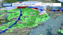
Regarding the chance for rain, Monday night will open the gate to our next low pressure system moving out of the Great Lakes into New England by Tuesday, which should increase the chance for more widespread rain and the drop in temperatures after.

This low will only bring rain to much of New England, with the exception of northern Maine, which may see some brief snow Monday night.


