Around this time each year, everyone starts wondering -- and speculating -- about how much snow we'll see during the upcoming winter season. And for good reason -- snowfall plays a huge role in people's commutes, the region's economy and our moods!
Our NBC10 Boston First Alert weather team is still working on its official prediction for this winter's snowfall. But already we've seen several others come out with their thoughts on what we can expect.
The Old Farmer's Almanac and the Farmer's Almanac (yes, they're two different publications!) have come out with their less than scientific predictions. And the National Oceanic and Atmospheric Administration and AccuWeather have released their forecasts as well.
Here's a quick look at what they're all saying, and remember, we'll be back soon with NBC10 Boston's official look at what to expect from this winter's weather.
Old Farmer's Almanac and Farmer's Almanac winter forecasts
First of all, what's the difference between the two publications?
The Old Farmer's Almanac is published in Dublin, New Hampshire, with the recognizable yellow cover, and dates back to 1792, while the Farmer's Almanac and its customary orange color is a product of Lewiston, Maine, and dates back to 1818. Both offer an opportunity to thumb through forecasts a couple of days at a time all the way through the upcoming year.
As NBC10 Boston Chief Meteorologist Matt Noyes told you when their forecasts were released back in August, these advanced forecasts are quite unpredictable, because they hinge upon the high impact of exactly where the jet stream winds establish for the winter. That's why NBC10 Boston's First Alert weather team typically waits until late fall to give its winter prediction.
But the almanacs can still give us some clues as to what we might expect.
This winter, it appears as though a La Niña pattern – cool water in the Pacific near the equator – will be a player in the atmosphere, encouraging milder-than-normal conditions in the Southern United States with drier-than-normal conditions particularly in the South-Central and Southwest U.S., with colder air spilling particularly into the Plains, Midwest and Great Lakes, and a clash of air resulting in an active storm path of mixed snow, ice and rain events across the Northeast.
It’s no surprise, therefore, that both the Old Farmer’s Almanac and Farmer’s Almanac reflect almost this exact weather pattern in their predictions.
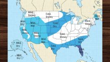
The Old Farmer's Almanac says it's a "Tale of Two Winters," with winter weather essentially splitting the country in two. The Northeast is expected to be very cold, and very snowy.
"The eastern half of the U.S. should brace for potentially record-breaking cold to define the season," their forecast says. Snowfall will be "greater than normal from central New England through northern North Carolina, from the Lower Great Lakes and the Ohio and Tennessee Valleys into the southern Plains, from the northern Plains into eastern Washington, and across the higher terrain of the southern Rockies and California."
Their Northeast-specific forecast says winter temperatures will be "above normal in the north," with the coldest periods in early and late January and February. They said precipitation will be above normal, but snowfall will be below normal in the north.
Here's a look at their map:
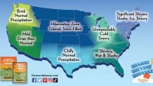
The Farmer's Almanac, meanwhile, is calling for a winter season with plenty of "snow, rain and much -- as well as some record-breaking cold temperatures!" They say the first bite of winter will likely come earlier this year, with December looking "stormy and cold nationwide." They're specifically highlighting the chance of heavy rain and snow across the eastern two-thirds of the country followed by "one of the coldest outbreaks of arctic air we've seen in several years" between Jan. 16 and Jan. 23.
Here's a closer look:
NOAA's winter outlook
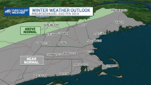
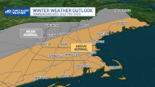
Turning more toward the science of weather forecasting, NOAA's Climate Prediction Center recently released its U.S. 2022-23 Winter Outlook, which calls for a warmer than average winter in New England.
As our own Tevin Wooten told you last week, the outlook examines the probability of precipitation and temperatures deviating -- above or below -- from a normal winter. NOAA’s outlook doesn’t look at specific cities, but instead climate groups and regions for northern New England, northeastern New England and southern New England.
The outlook says the Crown of Maine and areas north of the Presidentials will feature above normal chances for precipitation, while southern New England remains near normal for rain.
Here's a closer look at what's projected in terms of precipitation and temperatures for the Northeast:
AccuWeather's 2022-2023 winter forecast
Lastly, AccuWeather's 2022-23 winter forecast, determined by a team of long-range forecasters, says that this will be a snowy winter across "most of the northern tier of the contiguous United States."
As mentioned above, La Niña will play a major role in shaping weather patterns across the U.S.
AccuWeather's forecasters say that residents in the Northeast should expect to see a few winter previews in November and December, but the real cold will h old off until later in the season. New England is one of the only areas east of the Rockies that could see higher-than-normal snowfall, they said, with January and March "bringing the highest chances of powerful coastal snowstorms."
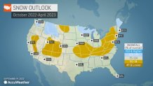
Boston could be the only major city along Interstate 95 that sees near-normal snowfall, they said, with between 40 to 50 inches accumulating in the city, which is right around the average snowfall of 49.2 inches and less than the 54 inches the city saw last year, mostly as a result of the 23-plus inches that fell during the Jan. 29, 2022, blizzard.

