Sunday featured a bit of a thaw across the area as the Arctic air loosened its grip on the region, but it will return again by the middle of the week!
A cold front will slide through the area Sunday night, bringing a few snow flurries and snow showers with it. A coating of snow is possible here and there, but we're not expecting much more than that.
Winds will turn out of the northwest behind the front and usher in colder air with clearing skies late Sunday night. Lows will drop into the teens in the south, into the single digits and lower further north.

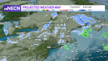
Clouds will increase from the west to east during Monday afternoon and evening ahead of an Alberta Clipper. That clipper will quickly move into the area late Monday night and Tuesday, bringing with it some snow showers, mixed precipitation and rain across southeast Massachusetts.
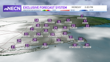
It'll be a cold start to the new work week with plenty of sunshine to start the day. Highs will range from the mid-20s to low 30s south, upper teens to low 20s north.
Right now, the system looks to be moisture-starved and shouldn’t pose too much of a problem as it passes through the area.
Current models, including our in-house NBC snow model, suggest a coating to as much as several inches of snow to portions of the area by Tuesday afternoon. Lesser amounts are expected across the southern portion of the region and higher amounts across the mountains of northern New England.

It’ll also be occurring during the Tuesday morning commute, so we’ll monitor it closely in case there are any changes.
Thereafter, Arctic air follows, bringing temperatures down considerably with bitter cold wind chills into Thursday.
Weather Stories
We are still watching to see if a coastal storm develops south of New England Friday into Saturday. It is still too early to call! Stay tuned…


