
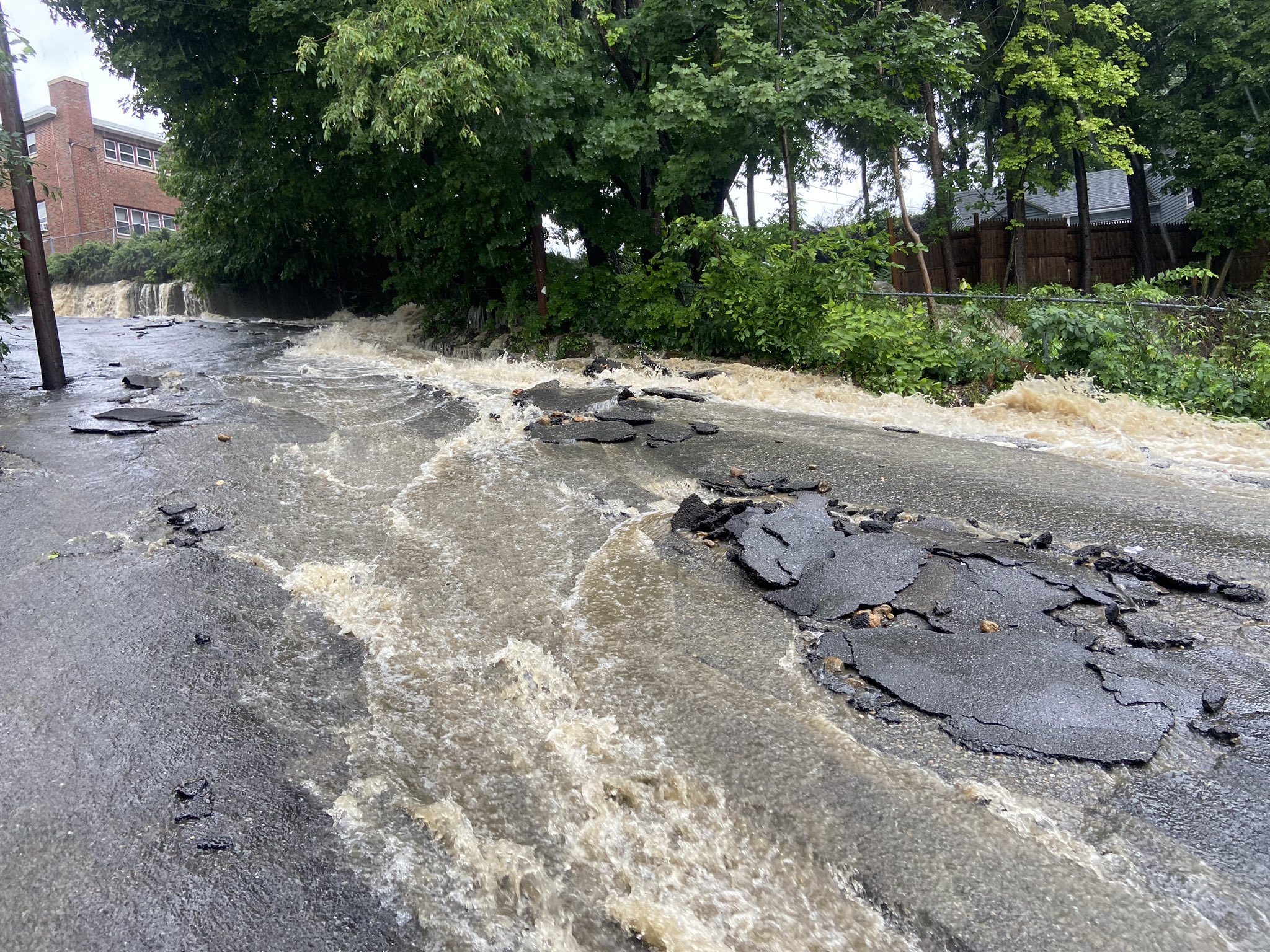
The National Weather Service issued numerous flash flood warnings on Sunday amid heavy rainfall, including in several Massachusetts counties such as Bristol, Suffolk, Norfolk, Worcester, Essex, Middlesex, and Plymouth counties.
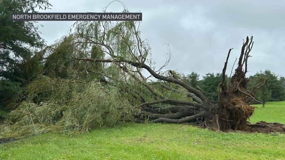
The NWS confirmed that an EF-0 tornado touched down in central Massachusetts earlier in the day.
The tornado touched down just before 11 a.m. in North Brookfield, west of Worcester, and had a path of 2 miles in length. There were no injuries or damage to homes.
Related stories
Earlier tornado warnings for Essex, Middlesex and Worcester counties in Massachusetts and Hillsborough and Rockingham counties in New Hampshire also expired, but tornado watches remained in effect through 3 p.m. for much of New England.
Severe thunderstorms capable of producing a tornado were located in the Chelmsford/Lowell area in Massachusetts and the Manchester/Pelham area in New Hampshire between 8 and 9 a.m. Another tornado warning was issued for the Raymond, New Hampshire, area just before 10 a.m. Tornado warnings were issued for the Townsend, Massachusetts area and the Brookline, New Hampshire, area a short time later. An earlier tornado warning was issued around 6 a.m. Sunday for Berkshire County in Massachusetts.
There was some indication that a tornado may have touched down in Maynard, Mass., but there has been no official confirmation as of yet.
Severe thunderstorm warnings were also issued for parts of Hampden, Hampshire and Worcester counties in Massachusetts and Tolland and Windham counties in Connecticut.
Click here for the latest severe weather alerts
Flash flood warnings in New England
As of 11 p.m. Sunday, there were no active flash flood warnings in New England.
Flash flood warnings issued earlier for Massachusetts, New Hampshire, Maine, Vermont, Connecticut, and Rhode Island have since expired, but flood warnings and river flood warnings remained in effect Sunday night for parts of Connecticut, New Hampshire, Rhode Island, Maine and Vermont.
PHOTOS: Flooding causes road closures in New England
Tornado watch through 3 p.m.
A tornado watch is remains in effect for parts of Connecticut, Massachusetts, southern Maine, New Hampshire and Rhode Island through 3 p.m., meaning conditions are favorable for tornadoes and severe thunderstorms.

A First Alert was issued Sunday for flooding rainfall heading our way. The storms and showers will be off and on all day long and there is even a chance for some severe weather.
Some areas were already reporting over 2.5 inches of rain as of 10:30 a.m.
Here's everything you need to know:
Timing
A flood watch is in effect for most of New England, 2am Sunday to 2am Monday for the heavy rain anticipated. About 1-3" of widespread rainfall is forecast, with some areas getting 3-5" or more.
A tropical transport of moisture marches in from the Gulf of Mexico and the Atlantic in the upper levels of the atmosphere and this means the skies are loaded with water.

So flash flooding, urban small, small stream, and even river flooding are all likely across the northeast, with the Weather Prediction Center putting western New England to just around Boston in the moderate or most likely category for excessive rainfall.
The showers and storms will be picking up by mid morning for all, and spreading southwest to northeast. Heaviest rainfall and storms will be during the afternoon and evening hours. With rain lingering through midnight and for predawn hours Monday.
Severe storm threats
While all the heavy rain occurs we have the chance for strong to severe embedded thunderstorms. These will bring higher rain rates of 2-4" per hour, lightning, and damaging straight-line winds, perhaps a brief spin up tornado.
There is an increasing low level jet and enough spin in the atmosphere to get about a 2% chance for a tornado anywhere in New England.

Extended outlook
Monday morning, there will be lots of flooded roads and low lying areas, so watch if you are heading out before sunrise as the flooded out roads will be difficult to see.
We dry off Monday morning and afternoon making for a warm and sunny day with highs in the upper 80s. Our great weather continues for most of next week.
Tuesday brings some storms overnight, after a day in the 80s again. Wednesday and Thursday we see some lower humidity and temps in the low 80s.
Scattered storms return by Friday into part of next weekend.
