This week already feels and looks like springtime! We changed our clocks forward one hour over the weekend and this means nice later sunsets.
As you head home from work, watch for solar glare on the road in different spots than you may be used to. Potholes are popping up everywhere again as we thaw out, and pollen from Juniper is increasing.
Everything in New England is waking up as we near the start to astronomical spring on March 20th. Before that, we have St. Patrick’s Day to celebrate on Thursday and this is the day we watch for a system to pass south.
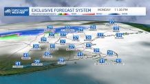
Today’s highs will be in the 40s to 50s south with a mix of clouds and sun. A near stationary front is draped across central New England the next few days so waves of precipitation will move through from time to time. No major issues, but tonight for example, we will see 1-2” of snow in the far north country overnight.

Meanwhile, temps continue to rise this week, to the 50s and low 60s by Thursday. Scattered showers will pass across southern New England Thursday afternoon and evening, so watch for some rain around Boston.
Temps continue to rise into Friday, with highs in the 60s at the coast thank to a sea breeze to 70s inland. Another storm system may bring in some rain for Saturday with temps in the upper 50s. Sunday we see highs in the mid 50s and for now it looks mainly dry.


